Highly detailed single-use zoning
Some cities maintain rigid single use zoning classifications but manage to allow mixed use anyway by having the border between a commercial and residential zone pass through the middle of a building or property, so that the two land uses can be right next to one another. This is another way that mixed-use happens in China, and is especially important in Ji’an, where planning officials are resistant to allowing significant mixing within a single zoning category.
Special administrative districts
Many cities, including major cities in China, either supplement or override single-use zoning within special zones. This sort of zoning overlay might designate mixed use only within such an overlay district, or it might simply require that planned developments submit their plans to a special administrative body which then uses their professional discretion to determine compliance.
No zoning
Some cities have no zoning at all, though they have some regulations governing developers. Houston, Texas is one such city.
Zoning classifications in the West are highly detailed. There are sometimes dozens of use categories, and usually additional categories for specific ‘user groups’. These detailed codes make it easier to avoid the sort of externalities that the single use zoning was intending to avoid, while typically permitting a mix of compatible uses. For instance, special commercial zoning categories for bars, clubs, and adult-oriented commercial activities are far more restrictive and limited in scope than zoning that allows offices and small scale retail.
Below is the zoning map for Madison Avenue in Midtown Manhattan, New York City.
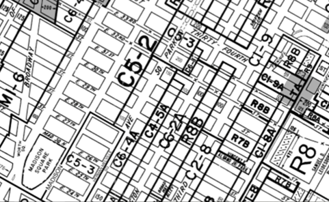 Fine-grained single use zoning with multiple sub-categories: Example from New York City Midtown.
The center of the area is zoned C5-2, which allows for an FAR of 10, with a 20% increase if there is a public plaza and another 20% increase if there is a public facility. It also allows for residential development following zoning code R-10. The lots with a letter after them, such as C6-4A or C6-2A, etc. are contextual commercial districts. This designation was first introduced with the zoning reforms of 1986. These districts are substantially residential in character, but are zoned as commercial in order to allow commercial development.
“In these districts, indicated by an A, D or X suffix, such as C4-4D, supplementary bulk regulations mandate that all developments maintain street wall continuity and a harmonious relationship with other buildings in the area.”
Source (nyc.gov)
Among the Chinese cities reviewed, both Shanghai and Shenzhen encourage mixed use zoning in specific conditions. Shanghai’s Technical Guidelines for Detailed Regulatory Planning (provision 3.3.1) states the following:
“To encourage public activities, central areas, historical districts, transit hubs, and waterfronts, should encourage such mixing of land use... Land use categories with similar functions, use, and environmental requirements, with no adverse effects on each other, and of mutual benefit to each other, should be mixed.”
The provision includes detailed tables of which sorts of land uses are compatible with each other.
 Table of compatible land uses, Shanghai.
The Standards and Guidelines for the Urban Planning of Shenzhen (深圳市城市规划标准与准则 - updated in February 2017) includes similar provisions. Provision 2.2.1.3 has modifications of the designations for land use that are contained in the national Code for Classification of Urban Land Use and Planning Standards of Development Land (城市用地分类与规划建设用地标准 - GB 50137 – 2011). For example, the Shenzhen classifications provide an additional 'R4' residential classification covering mixed use urban villages built by original area residents, and the business & commercial categories are greatly simplified compared to the national code. Warehouse & logistics categories are also simplified, and the Shenzhen code includes an 'S9' covering refueling facilities that is not included in the national code.
However, for the key measures influencing TOD, the modifications to the land use categories in Shenzhen do not appear to be the essential enabling factors. Put another way, the national land use code does not present a barrier to to implementation of mixed use or mass transit station area zones. Designations applied to station area development zoning in Shenzhen such as S3 (literally mentioning 'rail', but relating to major transit hubs which could be considered as including major BRT stations) and S4 (relating to transit facilities more generally) are provided in the national code which is applied in Ji'an, and mixed use is envisaged under the national code, as explained below.
In areas designated as city centres and important commercial areas and public service areas in Shenzhen, two types of land use are encouraged to be mixed: R2 and C1, or highrise residential and commercial & business uses. Along rail mass transit lines (land use code S3), Shenzhen specifically encourages the mixing of S3 + R2 and S3 + C1 (highrise residential and commercial), and allows the mixing of S3 with dormitory style residential and sports facilities (GIC2 and R3).
Mixes of land uses encouraged and allowed in Shenzhen.
表2.2.3.4 常用土地用途混合使用指引
| 用地类别 |
鼓励混合使用的用地类别 [mix encouraged] |
可混合使用的用地类别 [mix allowed] |
| 大类 [main category] |
中类 [sub-category] |
| 居住用地(R)[residential] |
二类居住用地(R2) |
C1 |
|
| 三类居住用地(R3) |
C1 |
M1、W1 |
| 商业服务业用地(C)[commercial] |
商业用地(C1) |
|
GIC2、R2 |
| 公共管理与服务设施用地(GIC)[institutional] |
文体设施用地(GIC2) |
|
C1 |
| 工业用地(M)[industrial] |
普通工业用地(M1) |
W1 |
C1、R3 |
| 物流仓储用地(W)[warehousing] |
仓储用地(W1) |
M1 |
C1、R3 |
| 交通设施用地(S)[transport] |
轨道交通用地(S3)[rail transit] |
C1、R2 |
GIC2、R3 |
| 交通场站用地(S4)[transit land] |
C1 |
GIC2、R3 |
| 公用设施用地(U)[utilities] |
供应设施用地(U1) |
|
G1、GIC2、S4 |
| 环境卫生设施用地(U5) |
|
G1、GIC2、S4 |
Standards and Guidelines for the Urban Planning of Shenzhen, Section 2.2.3.4, emphasis added.
Potential mass transit categories are S3 and S4. Highrise residential (R2) is encouraged to be mixed with commercial (C1). Industrial areas can also be used for commercial uses (offices, retail, hotel, etc).
In other Chinese cities including Ji'an, even where there is no direct encouragement of mixed use, either the zoning map is sufficiently detailed that single buildings have multiple zoning designations, allowing for the mixing of commercial and residential or office and commercial in the same building, or the zoning designation can still allow uses which are not the same as the primary use, especially complementary uses. The national code applicable in Ji'an lists the complementary uses allowed for some categories.
Municipalities in Jiangxi Province, including Ji’an, use a Euclidean zoning system based on broad categories of land use set out in the national code GB 50137 – 2011: residential, commercial, industrial, public service facility, etc. A few cities in China such as Shanghai and Shenzhen, as described above, provide a different set of categories, but they remain broadly consistent with the national code.
Mixed use development in the same land is encouraged.
[提倡同一地块内不同使用功能的混合开发]
Ji'an, like other cities in China, does not have a zoning classification for ‘mixed use’, but the national code applicable in Ji'an anticipates and does not disallow mixed land uses, and the provincial zoning code encourages mixed use. The national code stipulates that single developments with multiple different uses should be classified for the zoning purposes according to their main use. (Shenzhen's code is more explicit in actually encouraging or allowing such mixing of land uses.) Therefore, there seems to be flexibility and opportunity at the city level to provide greater detail to supplement the national code on land uses and to encourage or at least allow more mixed land uses. Mixed land uses could be encouraged or allowed either for all highrise apartments areas in the city (as is the case in Shenzhen), or at least in BRT station areas, drawing from the S3 and S4 land use categories related to mass transit stations.
The Jiangxi Province City Planning and Zoning Guidelines which are applicable in Ji'an encourage mixed use development. Article 2.1.2 on the first page of this regulation states that:
"2.1.2. The usage and location of development projects should follow the principle of compatibility. [...] Mixed use development in the same land is encouraged. The ratios and development scale for each usage shall be defined in regulatory & detailed planning, and shall be included as a condition of a plan."
["2.1.2 各类建设用地的使用和建设项目的选址遵循土地使用兼容性的原则,建设用地的兼容性规定应在控制性详细规划中明确。建设用地性质与规划用地性质属同一用地中类的,视为可兼容用地。 提倡同一地块内不同使用功能的混合开发,混合开发地块各功能用地比例、建设规模应当在控制性详细规划中明确,并纳入规划条件中。"]
Section 2.1.2 of the Jiangxi guidelines also stipulate that, "The compatibility rules of development land shall be defined in regulatory & detailed planning", and Ji'an planning officials are currently working on this planning.
The new zoning map of Ji’an has a sufficiently fine grain in specific locations to allow for mixed-use development within a single block. However, there are relatively few such areas in the planned BRT corridor. Such zoning is most prominent in the southern part of the city on both the western and eastern sides, a block or two set back from the riverfront. Note however that both the national and provincial codes envisage implementation of mixed use developments which are compatible with a single use zone. For example in a commercial zone, provided the main character of the development is commercial, a development could include residential apartments, retail, business offices and a parking garage and still be classified as 'commercial'.
"The land classification of this standard is divided and classified according to the main nature of the actual use of land. Land with multiple uses shall be classified on the basis of the nature of the facilities used for its main use. Considering for example a high-rise multi-functional integrated building where the ground floor has shops, floors 2-15 are business offices, floors 16-20 are apartments and the basement is a parking garage, the property is mainly business office, so it is classified as "commercial facilities land" (B2). If the main nature of the use of the complex is difficult to ascertain, categorize according to the primary nature of the underlying use."
[本标准的用地分类按土地实际使用的主要性质或规划引导的主要性质进行划分和归类,具有多种用途的用地应以其地面使用的主导设施性质作为归类的依据。如高层多功能综合楼用地,底层是商店,2~15 层为商务办公室,16~20 层为公寓,地下室为车库,其使用的主要性质是商务办公,因此归为“商务设施用地” (B2)。若综合楼使用的主要性质难以确定时,按底层使用的主要性质进行归类。]
Source: Code for Classification of Urban Land Use and Planning Standards of Development Land (城市用地分类与规划建设用地标准 - GB 50137 – 2011), Section 3.1.1.
 Ji'an Zoning Map 2016 - 2030 shows blocks where the land use category is divided within the block. Red is retail commercial, orange is commercial offices, purple is public services and government offices, and yellow is residential.
The current zoning applied in the station areas of the planned BRT system is shown below. In the Ji’an city centre, the zoning around the planned BRT stations (below) is largely for single use by block, with large blocks of commercial or residential land uses. A few blocks are broken up by some schools (in purple), and a few have both residential and retail on the same block.
As discussed above, though, this single-use designation does not prevent the implementation of mixed-use developments in Ji'an or other cities. The balance of compatible uses allowed while staying within the primary classification is not defined by either the national or provincial regulations, and is left to city authorities to determine in city level regulations. (Ji'an planning officials say they are working on this.)
The Ji'an planning authorities in interviews with Far East Mobility say they apply a restrictive approach in which a maximum of only around 7% of a development may be used for uses which do not match the primary zoning classification. Allowing a higher proportion of mixed uses in developments along the BRT corridor or around BRT stations may therefore be something that could be solved simply by the Ji'an authorities applying a less restrictive approach to allowing land uses outside the primary classification, say up to 50% or more of a development instead of the current informally applied 7%.
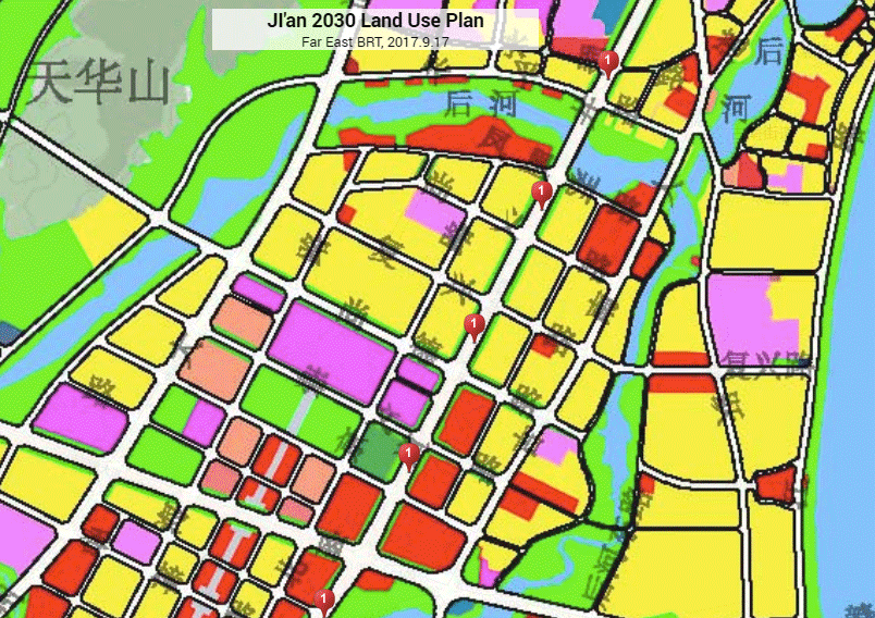
 Current zoning, stations areas, Ji'an central area. The centre of the proposed BRT stations are shown by red markers.
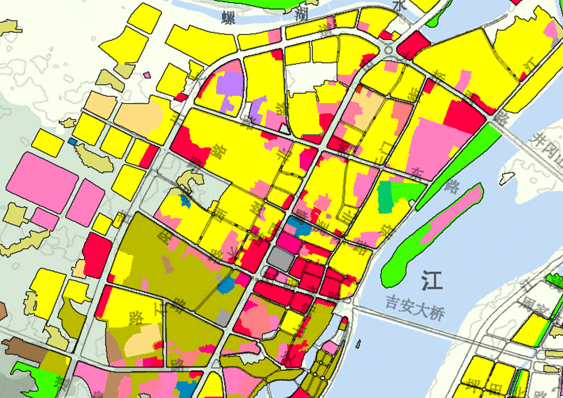 Existing land uses, Ji'an central area.
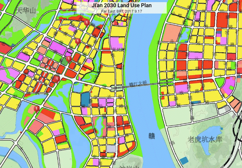
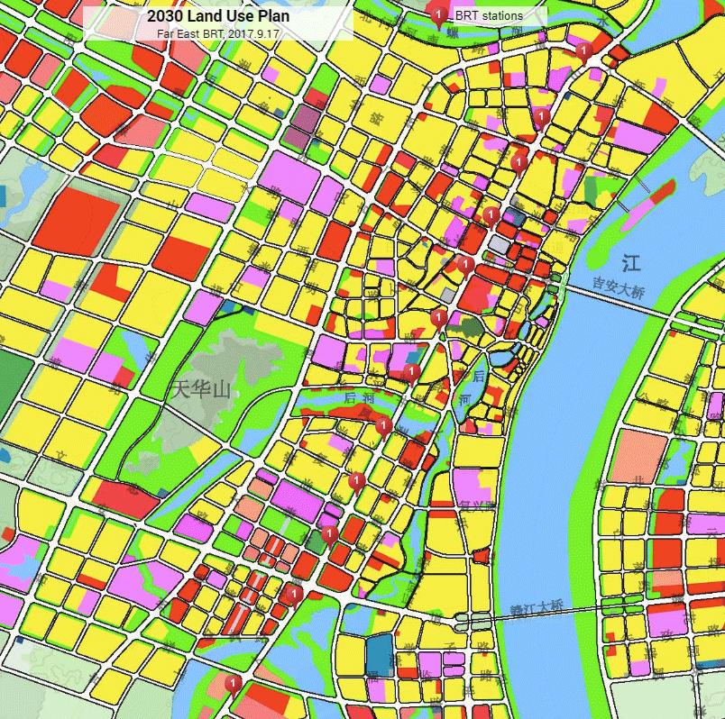
When this land use plan for 2030 (from 2016) is compared to the current land use (shown above), it shows that the current regulatory direction is towards reducing rather than increasing the level of mixing of compatible land uses in the urban core. Several blocks with existing mixed land uses (retail on the main BRT corridor and residential behind it) have been rezoned for single use, either all commercial or all residential.
While this area is already built up, in China it is not uncommon for land use to change rapidly, particularly along a BRT or metro corridor. As such, without a special ‘transit area’ approach to allowing a higher proportion of uses outside the primary designation, it is possible that many of the existing mixed use developments in the Ji’an central business district will be replaced with single use buildings to comply with the current zoning regulation.
Moving south, the next major area of Ji’an is Guan Di Shang, the area being newly developed around the municipal offices. Much of this area is currently still under construction. The zoning is almost entirely for large blocks of single use zoning: three superblocks of residential followed by several superblocks of commercial. As this area is currently rapidly being developed, a transit station area overlay or planning bureau approach not only allowing but encouraging greater land use mixing (while retaining compabitility with the zoning code) could make a big difference to how this area develops, though it is probably already too late for some of the developments.
 Current zoning, Guan Di Shang, the new city government administrative area in Ji’an.
The southern terminus of the BRT corridor travels through another open area being land-filled that is currently rapidly developing, followed by another largely built up area, Ji'an County.
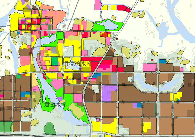 Existing lane use, as of around 2015, in the Ji'an County area.
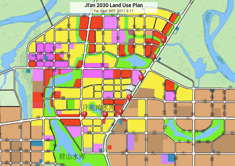 Current zoning, Ji'an County (BRT stations marked in red).
The pattern is similar to the zoning changes in southern and central Ji’an City. Large single use superblocks are being planned for the new development areas, and the mixing of land uses in the built-up areas is being further reduced by an approach being taken by Ji'an planning officials which discourages or disallows uses which are not within the primary land use designation. (As noted, this restrictive approach is not required in either the national or provincial codes.)
As Ji’an does not yet have a rapid transit system, it does not yet apply approaches such as those used in Shenzhen to encourage the mixing of land uses around mass transit stations or corridors, but there does not appear to be anything in the national or provincial codes which would prevent Ji'an from adopting such an approach. If Ji'an issued a regulation stating that a higher proportion of mixed uses would be allowed around the BRT stations, such a regulation would not be in contravention of either the National Code for Classification of Urban Land Use and Planning Standards of Development Land GB 50137 – 2011 or the Jiangxi Provincial City Planning and Zoning Code, which encourages cities to adopt mixed-use developments.
With the introduction of BRT in Ji’an, it should therefore be possible to introduce, following the examples of Shanghai, Shenzhen and other cities, approaches which would encourage or at least allow the mixing of commercial, residential, public service, and office land uses within 500 meters of the BRT stations, without any departure from standard practice in China. The new approach encouraging mixed use around BRT stations and along the BRT corridor could be documented as part of the regulatory and detailed planning which the provincial guidelines envisage will be prepared by cities including Ji'an.
Density
High density development around mass transit station areas is one of the central tenets of transit-oriented development and the integration of land use and transport. Dense station areas maximize the network efficiency and economic benefits of transit system investments, ensure that station areas are lively and thrive economically, and create a market in passengers for the transit systems. Planning high density land use around stations also creates opportunities for the government to capture some of the value from mass transit.
Chen Dun Peng and Xiao Sheng from the Shenzhen Urban Planning & Land Resource Research Center explained in an interview with Far East Mobility on 19 September 2017 that Shenzhen looked to best practices from around the world to guide its standards formulation, and the area of density was one area in which a strong case could be made that all parties - government, private citizens, and developers - can benefit, which makes it easier to implement any new approach.
Shenzhen applies a formula to adjust the base density level upward for areas in close proximity to mass transit stations. The basic formula applied is FAR规划=FAR基准× (1+ A1) ×(1 + A2)…; in which A1, A2, ... An represent adjustment factors for considerations including proximity to metro stations, number of sides which have roads, and the plot size.
An adjustment factor is applied to the base density allowed, defined as the Floor Area Ratio (FAR) in the case of areas within 200m and 500m of metro stations:
Increased density allowed within 200m and 500m of metro stations in Shenzhen.
"居住用地、商业服务业用地地块容积率应根据地块周边地铁站点等级及覆盖情况进行容积率修正。车站综合定位分成枢纽站和一般站两类;以站点几何中心作为规定半径计算基点,规定半径分别为0~200米和200米~500米两个等级;对跨越不同规定半径的地块,宜依据相应的修正系数和影响范围面积加权平均,折算到整个地块;远期实施的地铁线路站点原则上不考虑修正。地铁站点修正系数宜按表4.2.9的规定确定。"
表4.2.9 地铁站点修正系数 [Metro station location correction factor]
| 区位情况 [location situation] |
距离站点(米)[distance (m)] |
修正系数 [adjustment factor] |
| 枢纽站 [major station] |
一般站 [normal station] |
| 车站综合定位 [station location] |
0~200 |
+0.60 |
+0.40 |
| 200~500 |
+0.40 |
+0.20 |
Standards and Guidelines for the Urban Planning of Shenzhen, Section 4.2.9 (深圳市城市规划标准与准则)
Ji'an could adopt a similar approach of allowing higher density development in a range of 200m and 500m of BRT stations. The current density maximum from the Jiangxi Province planning and zoning regulation is only 2.8 FAR for a highrise residential development greater than 50,000m2 floor area, up to 3.5 FAR for a development with less than 10,000m2 floor area. For commercial developments, the maximum allowable FAR ranges from 4.5 to 5.5 depending on the building size. Shenzhen defines six density classes. The highest two classes allow for a maximum FAR of 6 for residential developments, and the highest class provides for a maximum FAR of 15 for commercial developments in the city centre.
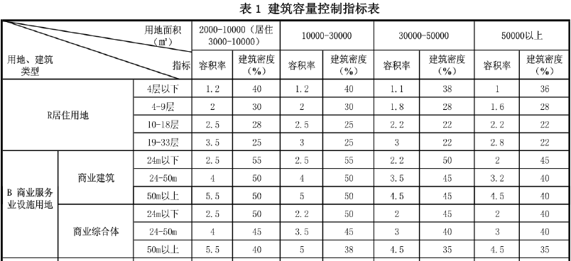 Maximum FAR allowed under the Jiangxi provincial zoning regulations in force in Ji'an. 'R' is residential and 'B' is commercial. The top row is the floor area of the development, and the left column refers to a range of building heights (in metres or floors). The percentage refers to the building coverage of the site area.
表4.2.4 居住用地地块容积率指引 [FAR guidelines - residential land]
| 分级 |
密度分区 [density level] |
基准容积率 [benchmark] |
容积率上限 [upper limit] |
| 1 |
密度一、二区 |
3.2 |
6.0 |
| 2 |
密度三区 |
2.8 |
5.0 |
| 3 |
密度四区 |
2.2 |
4.0 |
| 4 |
密度五区 |
1.5 |
2.5 |
表4.2.5 商业服务业用地地块容积率指引 [FAR guidelines - commercial land]
| 分级 |
密度分区 [density level] |
基准容积率 [benchmark] |
容积率上限 [upper limit] |
| 1 |
密度一区 |
5.4 |
15.0 |
| 2 |
密度二区 |
4.2 |
10.0 |
| 3 |
密度三区 |
3.2 |
8.0 |
| 4 |
密度四区 |
2.4 |
5.5 |
| 5 |
密度五区 |
1.8 |
4.2 |
Standards and Guidelines for the Urban Planning of Shenzhen
The explanatory report accompanying the Standards and Guidelines for the Urban Planning of Shenzhen also cite the cases of Hong Kong and Ningbo. In Hong Kong, the highest FAR category applying to buildings with a height of 61m or higher in proximity to major metro stations is 10, with a permitted plot coverage of 40%. (The maximum plot coverage of 40% is the same as the maximum in the Jiangxi regulations). Ningbo also adjusts the maximum FAR according to proximity to metro stations, using the same categories as Shenzhen: less than 200m from a station, and 200m-500m from a station. Like Shenzhen and Hong Kong, Ningbo takes plot size into account, with higher FAR allowed for smaller plot sizes. The maximum FAR in Ningbo for sites within 200m of metro stations is 9 for commercial use, and 4 for residential use.
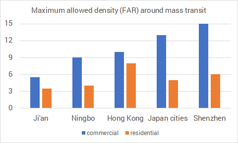 Maximum allowed FAR around mass transit stations, for commercial and residential land use.
Finally, it can be noted that Shenzhen's approach to encouraging mixed use developments in proximity to mass transit facilities is reflected in the calculations of maximum allowable density. For mixed use developments, the adjustment factors for the baseline FAR take into account the proportion of the development that is allocated to each of the different uses, noting that the allowable commercial FAR is higher than the maximum residential FAR.
Conclusion
The Jiangxi Province zoning and planning guidelines enable the individual cities to develop implementing guidelines, and these guidelines can be used by Ji'an to bring the city into line with international and national best practices in TOD in the key areas of mixed use and density. For implementation of mixed use, neither the national nor provincial guidelines present an obstacle to Ji'an allowing and encouraging a mixing of compatible land uses in BRT station areas. Allowing higher maximum density in BRT station areas than is currently stipulated in the provincial guidelines could be approached based on the special circumstances provisions of the provincial guideline. For density, mixed use and other TOD aspects, Ji'an should codify proximity to BRT stations as a factor influencing the planning approaches defined in the detailed implementing regulations which are currently being prepared pursuant to the provincial guidelines.
The next part of this series on TOD in Ji'an will consider best practice and recommended approaches to pedestrian facilities and building setbacks, and will summarize the proposed TOD measures and improvements in Ji'an.
Continue to part 3 on Ji'an TOD, covering parking, street network, pedestrian realm and setbacks. Later articles related to TOD in Ji'an will document proposed parking improvements, including an on-street parking management zone in the central area, proposed pedestrian facility improvements in the central area, and a detailed case study of the outstanding Ru Lin Li mixed use development. The ongoing BRT project will also be featured when the key design features are finalized.